Sep 18
Choosing Laser Scanning Equipment
Key Factors When Choosing Laser Scanning Equipment
Several critical aspects guide our decision in selecting the most suitable laser scanning tools for each project:
- Accuracy and Precision: Ensuring that the data captured is highly reliable.
- Detail Requirements: - Determining the level of detail needed for effective modeling.
- Speed and Resolution: - Balancing the scanning speed with resolution to meet project timelines without compromising quality.
- Range Capabilities: - Choosing equipment with the appropriate range to cover all required areas.
- Minimizing Facility Disruptions: - Selecting tools that work efficiently with minimal impact on ongoing operations.
- Cost Efficiency: - Optimizing equipment selection to deliver results within budget constraints.
- Reducing On-Site Visits: - Utilizing technology that minimizes the need for multiple scanning sessions.
- Adaptability to Environmental Conditions: - Ensuring the equipment can handle various environmental challenges on-site
Great. I’ll compare laser and LiDAR scanning equipment used in construction projects, focusing on five key criteria: cost, accuracy, speed, battery life, and range. I’ll identify models that perform well across each dimension and provide guidance based on different construction use cases
I’ll let you know as soon as I have the results ready for you.
Choosing Laser and LiDAR Scanning Equipment for Construction
Laser scanning and LiDAR technology have become indispensable in modern construction for capturing accurate 3D representations of sites and structures. Choosing the right scanner involves balancing cost, performance, and practicality. This article compares various terrestrial (tripod-mounted) and handheld/mobile 3D scanners, focusing on key criteria like cost, accuracy, scanning speed, battery life, and range. We also highlight recent models (2023–2025) and explain which scanners suit different project types (site surveys, BIM modeling, progress tracking).
Key Factors in Evaluating Laser/LIDAR Scanners
When comparing laser/LiDAR scanners for construction use, consider the following five criteria:
- Cost: Prices range widely. High-end terrestrial laser scanners can cost tens of thousands of dollars, while entry-level or smaller units are more affordable. For example, a compact scanner like the Leica BLK360 started around $18k–$20k ( Leica BLK2GO price – Candrone ), whereas a high-performance scanner like the Leica RTC360 or NavVis VLX can be $60k–$80k ( Leica BLK2GO price – Candrone ) ( Leica BLK2GO price – Candrone ). Factor in not just the unit price but also software, accessories, and maintenance costs.
- Accuracy: This denotes the level of detail and precision in measurements. Terrestrial laser scanners typically offer millimeter-level accuracy (e.g. ~2 mm at 10 m for a Faro Focus Premium (FARO Focus Premium) or 1.9 mm at 10 m for Leica RTC360 ( Leica BLK2GO price – Candrone )). Handheld or mobile scanners using SLAM may have lower accuracy, often in the 5–20 mm range depending on device and environment (BLK2G0 vs. Navvis VLX | Laserscanner.info) ( Leica BLK2GO price – Candrone ). Higher accuracy is crucial for BIM modeling and structural as-builts, while a slightly lower accuracy might be acceptable for rapid scans or progress monitoring.
- Scanning Speed: Measured in points captured per second (or total scan time per setup). Faster scanners can densely capture surfaces quickly, reducing field time. Top-end models fire 1–2 million points/second (e.g. Leica RTC360 and Faro Focus Premium at 2M pts/s (FARO Focus Premium)). Smaller devices may capture a few hundred thousand points/sec (the new BLK360 G2 does 680k pts/s (Leica BLK360 G2 Laser Scanner - Which Should I Buy? - G2 Survey), and mobile units like BLK2GO about 420k pts/s (BLK2G0 vs. Navvis VLX | Laserscanner.info)). High speed is valuable for large site surveys or minimizing scanning interruptions on active construction sites.
- Battery Life: Longer battery life allows more continuous scanning in the field. Terrestrial scanners often run 3–4 hours per battery on average (e.g. ~4 hours for FARO Focus Premium (FARO Focus Premium Laser Scanner | SEP Geospatial), ~3.5 hours for Trimble X9 (Trimble unveils new X9 3D laser scanning system | Geo Week News)). Handheld scanners tend to have shorter operation times per charge – often 45–60 minutes for a unit like the Leica BLK2GO (BLK2G0 vs. Navvis VLX | Laserscanner.info), though some mobile mappers offer hot-swappable batteries or ~1.5 hours on a pack (NavVis VLX) (BLK2G0 vs. Navvis VLX | Laserscanner.info). Consider whether you can swap batteries on the go and how many battery packs are needed for a full day’s work.
- Range:The maximum distance at which the scanner can reliably capture points. Terrestrial LiDAR scanners usually have long ranges – for instance, the Faro Focus Premium can scan up to 350 m (FARO Focus Premium Laser Scanner | SEP Geospatial), and Trimble’s new X9 up to 150 m (Trimble unveils new X9 3D laser scanning system | Geo Week News). Some long-range survey scanners even reach 600m+ (useful for civil projects or mines). In building construction, moderate range (50–150 m) is often sufficient. Handheld devices have much shorter range; e.g. the BLK2GO maxes out at ~25 m (BLK2G0 vs. Navvis VLX | Laserscanner.info) (ideal for indoors), and SLAM scanners like GeoSLAM ZEB Horizon about 100 m in open areas (GEOSLAM). Ensure the range covers your project scale (large site vs. small room).
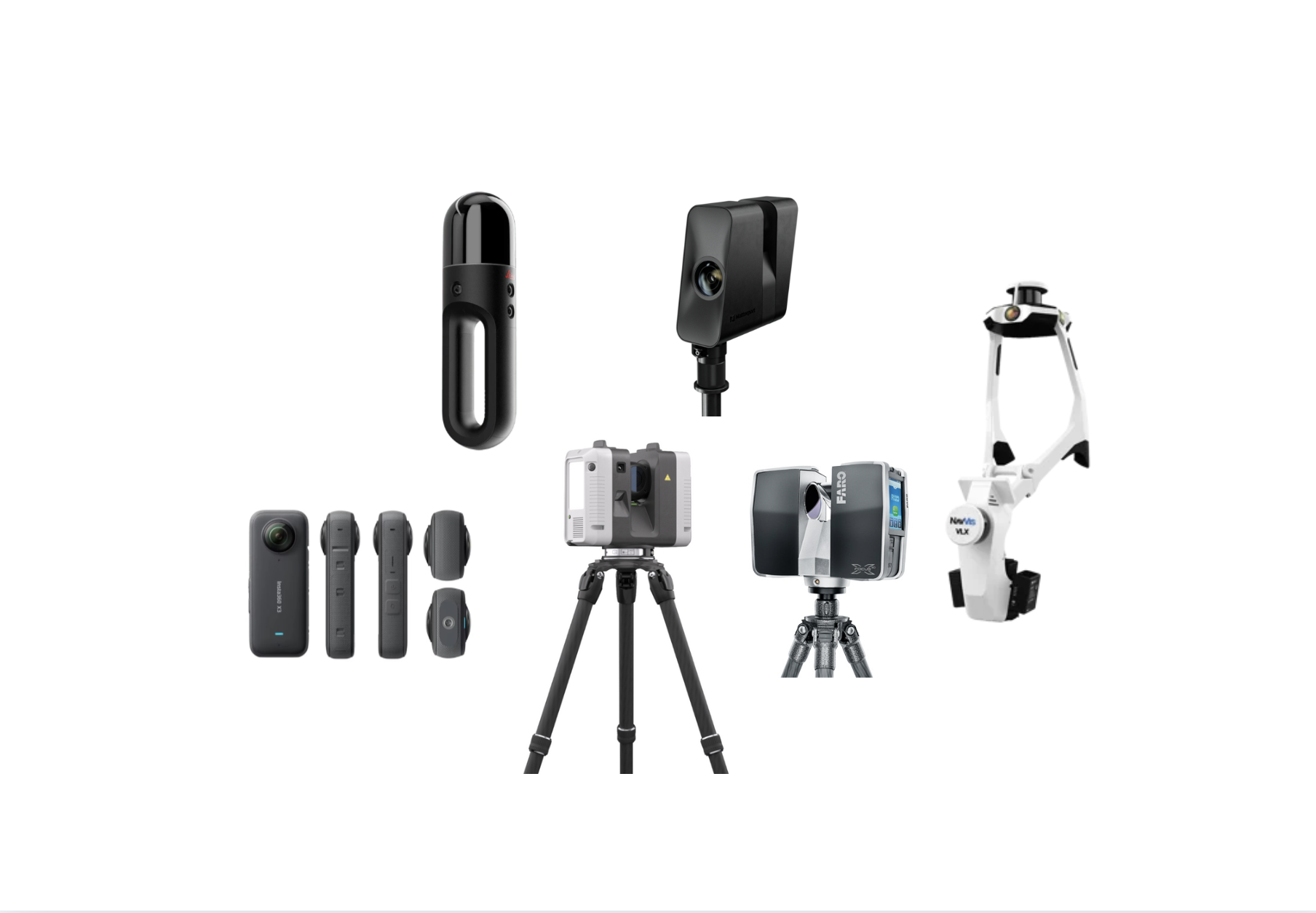
Types of Laser Scanners Used in Construction
Construction professionals typically use two broad categories of 3D laser/LiDAR scanners: terrestrial scanners and handheld/mobile scanners. Each type has strengths suited to particular tasks.
Terrestrial Laser Scanners (Tripod-Mounted)
(Trimble unveils new X9 3D laser scanning system | Geo Week News) A construction professional operates a tripod-mounted terrestrial laser scanner (Trimble X9) to capture a bridge structure, illustrating a common use of high-accuracy stationary LiDAR on site.
Terrestrial laser scanners (TLS) are mounted on tripods or survey stands and remain stationary during each scan. They rapidly spin a laser to capture the surrounding geometry in high detail. These scanners are known for excellent accuracy and range. In construction, TLS devices are used for site topography, building exteriors, interiors, and any application requiring precise as-built data.
Key features of terrestrial scanners include onboard sensors for leveling and sometimes automated registration. Many modern models capture high-resolution panoramic images alongside point clouds for colorized data. Examples of popular terrestrial scanners in 2023–2025 include the Leica RTC360, Leica BLK360 (Gen 2), Trimble X7/X9, Faro Focus Premium, and Topcon GLS series. For instance, the Leica RTC360 can capture 2 million points/sec with ~1-2 mmaccuracy and has a range of about 130 m ( Leica BLK2GO price – Candrone ) ( Leica BLK2GO price – Candrone ). The newer Trimble X9 (2023) similarly offers up to 150 m range at 1 M pts/sec with 2 mm accuracy (Trimble unveils new X9 3D laser scanning system | Geo Week News). These high-end scanners tend to be more expensive, but they excel in delivering dense, accurate point clouds quickly. They are often used for BIM modeling and complex structures where precision is paramount.
Mid-range terrestrial scanners like the Leica BLK360 G2 prioritize portability and ease of use. Weighing under 1 kg, the BLK360 can complete a full dome scan in 20 seconds and captures 680k pts/sec, with accuracy around 4 mm at 10 m(Leica BLK360 G2 Laser Scanner - Which Should I Buy? - G2 Survey). Its range is shorter (≈45–60 m) (Leica BLK360 G2 Laser Scanner - Which Should I Buy? - G2 Survey), but it is ideal for smaller spaces, quick as-built surveys, and teams new to laser scanning. Terrestrial units typically require moving the scanner to multiple positions (“setups”) to cover a large area, but advanced ones (RTC360, BLK360 G2, Trimble X7/X9) include internal IMUs or visual systems to assist in automatic cloud registration as you move between setups (Leica BLK360 G2 Laser Scanner - Which Should I Buy? - G2 Survey).
In summary, tripod scanners deliver superior accuracy and longer range. They are well-suited for detailed surveys of structures, exact measurements for prefab or clash detection, and any scenario where precision outweighs mobility. The trade-off is that they require line-of-sight and multiple setups to cover complex sites, and the units (plus tripod and accessories) are relatively bulkier.
Handheld and Mobile Scanners (SLAM-Based)
Handheld or mobile mapping scanners are portable LiDAR devices that you carry or wear to scan while moving. These use SLAM (Simultaneous Localization and Mapping) algorithms to continuously map the environment, which means you can walk through a site and capture data on the fly. This category includes devices like the Leica BLK2GO (handheld), GeoSLAM ZEB Horizon (handheld), and wearable systems like NavVis VLX.
Unlike terrestrial scanners, mobile mappers trade off some accuracy and range for speed and agility. They are extremely useful in environments that are complex, tight, or have many occlusions (e.g. inside buildings, MEP corridors, caves, multistory structures) where setting up a tripod repeatedly would be cumbersome. With a handheld unit, one can simply walk through each room and up stairwells, capturing as one goes.
Despite their convenience, it’s important to note performance differences. For example, the Leica BLK2GO has a LiDAR sensor capturing 420k points/sec and yields about 6–15 mm relative accuracy (~20 mm absolute) in real-world indoor scans ( Leica BLK2GO price – Candrone ). Its range is capped around 25 m ( Leica BLK2GO price – Candrone ), and it runs ~45 minutes per battery ( Leica BLK2GO price – Candrone ). This is sufficient for many interior documentation tasks and it excels at quick scans of entire floors or buildings in minutes. However, in open outdoor spaces or for applications needing higher precision, the BLK2GO’s shorter range and centimeter-level accuracy could be limiting (BLK2G0 vs. Navvis VLX | Laserscanner.info) (BLK2G0 vs. Navvis VLX | Laserscanner.info).
By contrast, higher-end mobile systems like the NavVis VLX (a wearable dual-LiDAR scanner) improve on these capabilities. The NavVis VLX offers up to 5 mm precision and a much longer effective range (it can detect points to 300 m, though useful range is ~100 m for good quality) (BLK2G0 vs. Navvis VLX | Laserscanner.info) (BLK2G0 vs. Navvis VLX | Laserscanner.info). It also has a faster data capture rate (two sensors at 640k pts/sec each) and about 1.5 hour battery life per pack (BLK2G0 vs. Navvis VLX | Laserscanner.info) (BLK2G0 vs. Navvis VLX | Laserscanner.info). The trade-off is the device’s weight (~8.5 kg worn on the shoulders) and cost – around €60k (roughly $65k), slightly more than the BLK2GO’s €48k ($60k) (BLK2G0 vs. Navvis VLX | Laserscanner.info). Mobile mappers like the VLX or GeoSLAM’s ZEB Horizon (handheld scanner, ~1–3 cm typical accuracy (GEOSLAM), 100 m range(GEOSLAM)) greatly speed up data collection for large facilities or sites with many nooks, albeit with less detail and accuracy than a terrestrial scanner.
In practice, handheld scanners are favored for speed and accessibility: they let users capture areas in a fraction of the time. For example, a BLK2GO can scan an entire room in ~10–20 seconds by walking through it, versus a few minutes for a static scanner setup ( Leica BLK2GO price – Candrone ) ( Leica BLK2GO price – Candrone ). This makes them ideal for construction progress captures (where quick periodic scans are needed) or preliminary surveys. Many firms use them to augment tripod scans: the terrestrial scanner provides a high-accuracy backbone, and the mobile scanner fills in hard-to-reach spots or speeds up scanning of less critical areas (FARO Focus Premium Laser Scanner | SEP Geospatial). The two datasets can be combined (some scanner ecosystems like FARO’s Focus Premium and Freestyle handheld are designed to snap together data sets (FARO Focus Premium Laser Scanner | SEP Geospatial)).
Summary: Handheld/SLAM scanners provide unmatched portability and speed, making 3D scanning possible in challenging environments and on tight schedules. They are best for moderate accuracy needs and indoors or complex layouts. For highest accuracy work or very large-scale outdoor scanning, terrestrial scanners (or drone LiDAR for expansive sites) remain the go-to.
Comparison of Selected Laser/LiDAR Scanners (2023-2025)
The table below compares several popular laser/LiDAR scanners used in construction, across the five key criteria. It includes both terrestrial (tripod) and mobile units, highlighting the differences in performance:
- Scanner (Type)Approx. Cost (USD)AccuracyScanning SpeedBattery LifeMax RangeLeica BLK360 (Gen 2, Terrestrial)~$20,000 ([Leica BLK2GO price – Candrone](https://candrone.com/blogs/news/leica-blk2go-price?srsltid=AfmBOopxi-YmS3IG4rAJIZ637JUrwLMoJeP52SgcvHvrfOh1sEMjcd1X#:~:text=Pricing)) | ~4 mm @ 10 m ([Leica BLK360 G2 Laser Scanner - Which Should I Buy? - G2 Survey](https://g2survey.com/blog/blk360-which-should-i-buy/?srsltid=AfmBOoq0INLxbsQmtmDs6mmnETd85F9vdUmmy2duGAzwA6jfoQnD0G5n#:~:text=Both%20BLK360s%20have%20the%20same,distance%20for%20the%20BLK360%20G1));
8 mm @ 20 m ([Leica BLK360 G2 Laser Scanner - Which Should I Buy? - G2 Survey](https://g2survey.com/blog/blk360-which-should-i-buy/?srsltid=AfmBOoq0INLxbsQmtmDs6mmnETd85F9vdUmmy2duGAzwA6jfoQnD0G5n#:~:text=Both%20BLK360s%20have%20the%20same,distance%20for%20the%20BLK360%20G1)) | 680,000 pts/sec ([Leica BLK360 G2 Laser Scanner - Which Should I Buy? - G2 Survey](https://g2survey.com/blog/blk360-which-should-i-buy/?srsltid=AfmBOoq0INLxbsQmtmDs6mmnETd85F9vdUmmy2duGAzwA6jfoQnD0G5n#:~:text=Image)) | ~70 scans per charge ([[PDF] Leica BLK360](https://shop.leica-geosystems.com/sites/default/files/2022-06/Leica_BLK360-SpecSheet.pdf?srsltid=AfmBOopPXpCMWtltswlzS64YBl6LeGILhj4adzV6uyL0Es_YRxZgVonX#:~:text=,1)) (internal batt.) | 45 m ([Leica BLK360 G2 Laser Scanner - Which Should I Buy? - G2 Survey](https://g2survey.com/blog/blk360-which-should-i-buy/?srsltid=AfmBOoq0INLxbsQmtmDs6mmnETd85F9vdUmmy2duGAzwA6jfoQnD0G5n#:~:text=Image)) | - | FARO Focus Premium (Terrestrial) | ~$50,000 (FARO Focus Premium) | ~2 mm @ 10 m; 3.5 mm @ 20 m (FARO Focus Premium) | 2,000,000 pts/sec (FARO Focus Premium) | ~4 hours (FARO Focus Premium Laser Scanner | SEP Geospatial) (swappable) | 350 m (FARO Focus Premium Laser Scanner | SEP Geospatial) | | Leica RTC360 (Terrestrial) | ~$80,000 ( Leica BLK2GO price – Candrone ) | 1.9 mm @ 10 m; 2.9 mm @ 20 m ( Leica BLK2GO price – Candrone ) (Leica BLK2GO price – Candrone ) | 2,000,000 pts/sec | ~3–4 hours (swappable) (How long does you Leica RTC 360 last? - Laser Scanning Forum) | 130 m ( Leica BLK2GO price – Candrone ) | | GeoSLAM ZEB Horizon (Handheld SLAM) | ~$38,000 ( ZEB Horizon – Moss Geospatial) | 1–3 cm (typical) (GEOSLAM);~6 mm relative (GEOSLAM) | 300,000 pts/sec (GEOSLAM) | ~3.5 hours (GEOSLAM) (swappable) | 100 m (GEOSLAM) | | Leica BLK2GO (Handheld SLAM) | ~$60,000 ( Leica BLK2GO price – Candrone ) | ~6–15 mm relative ( Leica BLK2GO price – Candrone);~20 mm absolute ( Leica BLK2GO price – Candrone ) | 420,000 pts/sec ( Leica BLK2GO price – Candrone ) | ~45 minutes ( Leica BLK2GO price – Candrone ) (per battery) | 25 m ( Leica BLK2GO price – Candrone ) | | NavVis VLX(Wearable SLAM) | ~$65,000 (≈€60k) (BLK2G0 vs. Navvis VLX | Laserscanner.info) | ~5 mm precision (BLK2G0 vs. Navvis VLX | Laserscanner.info) | 640,000 pts/sec (×2 LiDARs) (BLK2G0 vs. Navvis VLX | Laserscanner.info) | ~1.5 hours (BLK2G0 vs. Navvis VLX | Laserscanner.info) (hot-swap) | 100 m (300 m max) (BLK2G0 vs. Navvis VLX | Laserscanner.info) |
- Table: Performance comparison of various laser/LiDAR scanners for construction (recent models 2019–2025). Relative accuracy refers to local consistency (for SLAM devices), while absolute accuracy accounts for global error over distance. Cost is approximate; actual prices vary by region and configuration.
- Each of these devices has particular strengths. For instance, the BLK360 is an affordable way to get into laser scanning with decent accuracy, suited for smaller projects or as-built surveys. The Faro Focus Premium and Leica RTC360 are high-end workhorses – they cover large areas with great accuracy and speed, making them ideal for demanding survey workflows or detailed BIM models ( Leica BLK2GO price – Candrone ) (FARO Focus Premium). On the mobile side, the ZEB Horizon offers an accessible handheld solution for fast scanning of buildings with medium detail, whereas the NavVis VLX pushes mobile scanning to near-survey grade (at a higher price and weight) (BLK2G0 vs. Navvis VLX | Laserscanner.info) (BLK2G0 vs. Navvis VLX | Laserscanner.info). The Leica BLK2GO sits between – ultra-portable and simple to use, albeit with lower accuracy and range, geared towards quick scans of interiors (BLK2G0 vs. Navvis VLX | Laserscanner.info) (BLK2G0 vs. Navvis VLX | Laserscanner.info).
Matching Scanners to Different Construction Projects
The “best” scanner often depends on the type of construction project or task at hand. Different project scenarios benefit from different scanning capabilities:
- Site Surveys and Large Terrain Mapping: For surveying large outdoor sites (civil earthworks, road corridors, utilities or a broad construction site), range and speed are critical. Long-range terrestrial scanners or drone-mounted LiDAR are suitable. A scanner like the Faro Focus (350m range) or a RIEGL long-range LiDAR can capture extensive topography from a few setups (FARO Focus Premium Laser Scanner | SEP Geospatial). Accuracy needs are moderate (cm-level may suffice for ground surfaces), but the ability to cover lots of ground quickly is key. If the site is very large or hard to traverse, UAV LiDAR might be used to complement ground scans. Mobile mappers can also be used for surveying linear sites (e.g. walking along a road with a SLAM scanner), but keep in mind their drift over long distances. For site surveys, battery life and field robustness matter too – a device that lasts all day or has swappable batteries and is weather-resistant (many tripod scanners have IP54 ratings (FARO Focus Premium)) will reduce downtime.
- Building As-Builts and BIM Modeling: When creating detailed BIM models of existing structures (e.g. documenting an industrial facility or an as-built of a building for retrofit), accuracy and detail are top priority. Terrestrial scanners are often the tool of choice here because they provide millimeter accuracy and high-resolution point clouds. For example, scanning a complex mechanical room for BIM likely calls for a high-accuracy tripod scanner to capture all pipe locations within a few millimeters. Range is less important since you can move the scanner around inside, but line-of-sight constraints mean you’ll take many scans. This is where features like the RTC360’s automatic scan alignment (VIS) help streamline work (Leica BLK360 G2 Laser Scanner - Which Should I Buy? - G2 Survey). In tight spaces or multi-story interiors, a hybrid approach can shine: use a stationary scanner for critical areas and a handheld scanner to quickly sweep secondary areas or above-ceiling/attic spaces. The BLK2GO or ZEB Horizon, for instance, can rapidly capture hallways, stairwells, or ceiling voids that would be tedious with a tripod, and the data can be registered into the main point cloud. The result is a complete BIM-ready dataset with high accuracy where needed and faster capture where ultra-high precision is not as critical. For BIM uses, scanning speed is valuable (to minimize disruption in the facility), but not at the expense of accuracy – so choosing a scanner that balances both is important. Many new scanners (Trimble X7/X9, Leica BLK360 G2) aim to simplify use so that architects/engineers can operate them easily without surveying expertise.
- Construction Progress Tracking and Site Monitoring: Regular scanning during construction (e.g. weekly scans to track progress or verify installations) emphasizes speed, ease-of-use, and portability. Here, a slightly lower accuracy tolerance is often acceptable in exchange for quick data capture. Handheld and mobile scanners are very advantageous for progress tracking – a site engineer can walk through the construction site with a BLK2GO or a mobile backpack scanner and capture the current state in minutes. The point cloud can then be compared to previous scans or the design model to check progress, detect deviations, or monitor for issues. The speed of capture means minimal interruption to ongoing work, which is a big plus. Battery life might limit how much can be captured in one go, but with fast devices you can scan only the areas of interest (e.g. the newly installed elements that week) rather than the whole site. Additionally, smaller tripod scanners like the BLK360 G2 (which can do a scan in 20 seconds) can be deployed at multiple points on site quickly (Leica BLK360 G2 Laser Scanner - Which Should I Buy? - G2 Survey) – for example, set it up in a few key locations, press a button, and within a short time you have snapshots of the site that are accurate to a few millimeters. This is great for progress documentation, as the data is higher quality than a mobile scan and still relatively fast to collect. For safety or inaccessible areas of a site, a drone with LiDAR or photogrammetry could also be used for periodic surveys. In summary, for progress tracking, speed and ease trump ultra accuracy: a scanner that one person can use without much setup, and process quickly (potentially even cloud-based processing for rapid turnaround), is ideal. Cost can also be a factor here – since these scans occur frequently, a lower-cost unit that is “good enough” might be easier to deploy across multiple sites or teams.
- Specialized Tasks: Some construction scenarios have unique needs. For example, deformation monitoring of structures (checking if a beam is bending or a wall moving) demands high accuracy and repeatability – a survey-grade terrestrial scanner or a total station might be required rather than a SLAM device. Underground construction or tunneling might benefit from mobile scanners due to the linear nature (walking a tunnel with a SLAM scanner), but one must account for drift. Heritage building documentation (if part of a construction project or adjacent to one) might prioritize very high resolution and photography – certain scanners (like the Focus Premium with HDR imagery (FARO Focus Premium)) are better for capturing fine architectural details and textures for restoration work.
- Ultimately, no single scanner fits all needs. Large construction firms often employ a toolbox of scanning solutions: a long-range high-accuracy scanner for surveys and structural work, a rapid mobile scanner for interiors and quick checks, and maybe drones or photogrammetry for expansive areas. Evaluating your typical project requirements against the criteria – budget, needed accuracy, site size (range), and how quickly you need results (speed, workflow) – will guide you to an appropriate solution.
Conclusion
Laser and LiDAR scanning equipment can dramatically improve construction workflows by providing accurate 3D data for planning, modeling, and verification. Terrestrial scanners offer superior accuracy and range, making them ideal for detailed surveys and BIM-quality as-builts, albeit at higher cost and with more setup effort. Handheld and mobile LiDAR scanners provide flexibility and speed, perfect for rapid captures and complex indoor environments, though with somewhat reduced accuracy.
When choosing a scanner, carefully compare specs like accuracy, speed, battery life, and range in the context of your projects. A balance must be struck between performance and practical constraints like budget and manpower. The comparison of current models shows that the industry is moving toward faster, more user-friendly scanners across all tiers – even smaller units now deliver respectable accuracy and imaging (Leica BLK360 G2 Laser Scanner - Which Should I Buy? - G2 Survey) (Trimble unveils new X9 3D laser scanning system | Geo Week News), while high-end systems are becoming more efficient and automated. By matching the scanner’s capabilities to your project’s needs (survey vs. BIM vs. monitoring, etc.), you can significantly enhance productivity and confidence in the data.
Ultimately, investing in the right 3D scanning equipment will pay off in improved construction accuracy, fewer reworks, and better project outcomes, as has been demonstrated by the growing adoption of reality capture in the AEC industry (Trimble unveils new X9 3D laser scanning system | Geo Week News) (Trimble unveils new X9 3D laser scanning system | Geo Week News). Evaluate your options with the criteria above, leverage manufacturer specs and demos, and you’ll be equipped to choose the optimal laser/LiDAR scanner for your construction projects.
Sources: The information above was compiled from manufacturer specifications, industry case studies, and expert analyses. Key references include manufacturer brochures and websites.